Types of Clouds
A cloud is a visible mass of minute liquid droplets, frozen crystals, or particles suspended in the atmosphere above Earth. Clouds are formed when the air becomes saturated with water vapor. They play a crucial role in the weather by way of causing precipitation and reflecting incoming sunlight back into the atmosphere. International Cloud Atlas was developed by WMO as a standardized reference document for the identification and classification of different types of clouds. WMO currently recognizes ten different types of clouds which depends on where in the sky they form and their approximate appearance:
All these names are derived from their height as well as their shapes:
Types of Clouds: Height
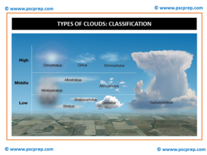
Based on the height of the cloud they are classified into:
- High Clouds: Cirro
- Middle Clouds: Alto
- Low Clouds: Strato
Types of Clouds: Shape
Based on the shape of the cloud they are classified into:
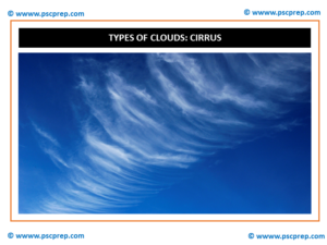
- Cirrus: Thin and linear
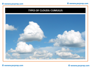
- Cumulus: Puffy or globule like
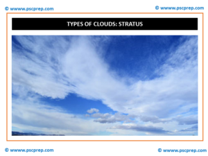
- Stratus: Sheet-like
Types of Clouds: Summary
In summary the combination of clouds looks like
- High clouds (CH): Cirrus, Cirrocumulus, Cirrostratus;
- Middle clouds (CM): Altocumulus, Altostratus, Nimbostratus
- Low clouds (CL): Stratocumulus, Stratus, Cumulus
- Cumulonimbus: Large vertical extent clouds
Types of Clouds: Detailed
Let us now look at these clouds in detail
Types of Clouds: 1: Cirrus: Cirrus clouds are high and thin. The air is very cold at high levels, so these clouds are made of ice crystals instead of water droplets. These are mostly fibrous wisps of delicate white ice crystals. Cirrus clouds are generally non-convective. They often form along a high altitude jet-stream. These high clouds do not produce precipitation.
Types of Clouds: 2: Cirrocumulus: They are small rounded clouds that usually appear in long rows high in the sky and are usually white, but sometimes appear grey. They show limited convection. They are composed of ice crystals or super cooled water droplets. Cirrocumulus occasionally forms alongside cirrus and may be accompanied or replaced by cirrostratus clouds at the very leading edge of an active weather system.
Types of Clouds: 3: Cirrostratus: They are high, very thin, non-convective and are composed of ice-crystals. It is difficult to detect and is capable of forming halos around the Sun resulting in refraction of the sun’s rays. The sun and moon are visible in clear outline
Types of Clouds: 4: Altocumulus: This is a mid-level cloud layer of limited convection that is usually appears in the form of irregular patches or more extensive sheets arranges in groups, lines, or waves. Altocumulus near the top of its range may resemble cirrocumulus but is usually thicker and composed of water droplets so that the bases show at least some light-grey shading. Opaque altocumulus associated with a weak frontal or low-pressure disturbance can produce virga, very light intermittent precipitation that evaporates before reaching the ground. If the altocumulus is mixed with moisture-laden altostratus, the precipitation may reach the ground.
Types of Clouds: 5: Altostratus: Altostratus is a mid-level opaque or translucent non-convective veil of grey/blue-grey cloud that often forms along warm fronts and around low-pressure areas. Altostratus is usually composed of water droplets but may be mixed with ice crystals at higher altitudes. Widespread opaque altostratus can produce light continuous or intermittent precipitation. Precipitation commonly becomes heavier and more widespread if it thickens into nimbostratus.
Types of Clouds: 6: Nimbostratus: It was formerly classified as low-level, but now considered by the World Meteorological Organization (WMO) to be a middle or multi-level type. Although it is usually a low-based cloud, it actually forms most commonly in the middle level of the troposphere and then spreads vertically into the low and high levels.
Types of Clouds: 7: Stratocumulus: This type is a cloud layer of limited convection, usually in the form of irregular patches or more extensive sheets similar to altocumulus but having larger elements with deeper-gray shading. Opaque stratocumulus can produce very light intermittent precipitation. It can create the illusion of continuous precipitation of more than very light intensity falling from stratocumulus.
Types of Clouds: 8: Cumulus: These are small detached fair-weather clouds that have nearly horizontal bases and flattened tops, and do not produce rain showers.
Types of Clouds: 9: Stratus: This is a flat or sometimes ragged non-convective type that sometimes resembles elevated fog. Only very weak precipitation can fall from this cloud (usually drizzle or snow grains), although heavier rain or snow may fall through a stratus layer from a higher precipitating cloud deck. When a low stratus cloud contacts the ground, it is called fog if the prevailing surface visibility is less than 1 kilometer, although radiation and advection types of fog tend to form in clear air rather than from stratus layers.
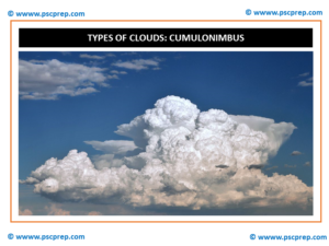
Types of Clouds: 10: Cumulonimbus: They are dense towering vertical clouds associated with thunderstorms and atmospheric instability, formed from water vapor carried by powerful upward air currents. Cumulonimbus can form alone, in clusters or along lines. These clouds are capable of producing lightning and other dangerous severe weather, such as tornadoes.
Types of Clouds: New additions to World Cloud Atlas 2017
The 2017 edition of the International Cloud Atlas has added 12 new cloud formations – one new species, five new supplemental features, one new accessory cloud type, and five new special clouds.
Species
Volutus: more widely known as roll clouds, a relatively rare formation influenced by wind shear.
Supplemental features
- Asperitas: wave-like billowing clouds with an “underwater” appearance
- Cavum: commonly termed “hole in a cloud”, “fallstreak hole”, or “hole punch cloud”, formed by ice crystals falling from a higher-altitude cloud of supersaturated liquid water droplets, leaving a round hole
- Murus: a new formal name for the “wall cloud”, seen at the base of supercell thunderstorms
- Cauda: a tail-like supplemental feature associated with wall clouds
- Fluctus: Kelvin-Helmholtz instability waves
Accessory cloud type
- Flumen: known as “beaver’s tail”, a type of trailing cloud associated with the inflow boundary of strong thunderstorms
Special clouds
- Cataractagenitus: waterfall spray
- Flammagenitus: clouds formed by intense heat; pyrocumulus
- Homogenitus: clouds formed by human activity, including aircraft contrails, ship tracks, and cooling tower fog
- Homomutatus: clouds that evolve from Homogenitus into persistent cloud cover
- Silvagenitus: clouds associated with cloud forests and from evapotranspiration above a forest canopy