Bharatmala Pariyojana: Overview
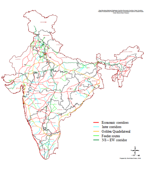
Bharatmala Pariyojana is a new umbrella program for the highways sector that focuses on optimizing efficiency of freight and passenger movement across the country by bridging critical infrastructure gaps through effective interventions like development of Economic Corridors, Inter Corridors and Feeder Routes, National Corridor Efficiency Improvement, Border and International connectivity roads, Coastal and Port connectivity roads and Green-field expressways.

Bharatmala Pariyojana: Background
The National Highways Development Program (NHDP) has reached a certain level of maturity. It is now important to re-define road development and have a macro approach while planning expansion of the national highways network. The focus has to be on recasting road development by bridging critical infrastructure gaps. Hence Bharatmala has been launched as a new umbrella program whose primary focus is on optimizing the efficiency of the movement of goods and people across the country. This program envisages a corridor approach in place of the existing package-based approach which has, in many cases, resulted in skewed development. For instance, in areas of high traffic, even upto 30,000 Passenger Carrying Units (PCUs), there are NH stretches of single and even intermediate lane. These have naturally become an impediment to seamless freight and passenger movement.
The NH Network and ongoing programs – India has about 54.82 lakh km of road network, which is the second largest in the world in terms of length. National Highways (NHs) constitute about 2% of the total road network, but carry about 40% of the total road traffic.
NHDP spread across Phase-I to VII is the most significant program taken up so far by MoRTH. In addition, MoRTH is implementing other important programs like Special Accelerated Road Development Program for North-Eastern Region (SARDP-NE) for development of roads in the North East, and also the Left Wing Extremism (LWE) Affected Area projects. Funding for these programs has been separately allocated. The program of upgrading single-lane National Highways to at least two-lane with paved shoulders through Externally Aided Projects (EAPs) is also being carried out. MoRTH is also implementing a comprehensive bridge building program called “Setu Bharatam” where 1,500 bridges and 208 Railway Over Bridges (ROB)s /Railway Under Bridges (RUBs) are being taken up. Other ongoing programs of MoRTH are – a special package for Jammu & Kashmir and NH(O).
NHDP had aggregate length of 55,792 kms. Out of this, 30,108 kms have been completed already and another 4,900 kms will be completed this year. The balance is 20,784 kms against which projects for 6,399 kms are under implementation. Of the remaining 14,385 kms, 4,385 kms are a part of Bharatmala Component like Corridors/Expressways. Unfinished outstanding stretches of 10,000 kms will be subsumed in Bharatmala and implemented as an integrated program. The extensive experience gathered by MoRTH and its implementing agencies like NHAI in implementing NHDP shall be utilized in implementing Bharatmala.
Identification of project stretches under Bharatmala
Bharatmala focuses on enhanced effectiveness of already built infrastructure, multi– modal integration, bridging infrastructure gaps for seamless movement and integrating National and Economic Corridors. Identification of the project stretches under the components of the proposed program has been done based on detailed O-D(Origin-Destination) study, freight flow projections and verification of the identified infrastructure gaps through geo mapping, using data from Bhaskaracharya Institute for Space Applications and Geo-Informatics (BISAG) as well as from other sources. This OD study has also taken into account integration of economic corridors with the ongoing projects under NHDP and infrastructure asymmetry in major corridors.
Bharatmala Phase I – components and outlay
As per the CCEA approval, Phase-I of Bharatmala shall be implemented over a period of five years i.e. 2017-18 to 2021-22. Summary of Phase I components and approved outlay for the same are as follows:
Components Length -km Outlay -Rs crore
- Economic corridors development 9,000 1,20,000
- Inter-corridor & feeder roads 6,000 80,000
- National Corridors Efficiency improvements: 5,000 100,000
- Border & International connectivity roads 2,000 25,000
- Coastal & port connectivity roads 2,000 20,000
- Expressways 800 40,000
a) Economic Corridors: – Identified Highways Corridors of Economic importance are expected to carry 25% of freight in the coming years. Once built, the National and Economic corridors along with their inter-corridor and feeder routes would be able to carry 80% of our freight traffic. Around 26,200 km of Economic corridors have been identified to be developed as Economic corridors out of which 9,000 kms are being taken up in Phase-I of Bharatmala.
b) Inter-corridor and feeder roads to National and Economic Corridors: – Around 8,000 km of inter-corridor and around 7,500 km of feeder routes have been identified out of which 6,000 kms are being taken up in Phase-I of Bharatmala.c) National Corridors Efficiency Improvement: The Golden-Quadrilateral and NS-EW, corridors carry 35% of India‟s freight and would be declared as National corridors. The average traffic in the 6 national corridors is >30,000 PCU. The 6/8 laning of these corridors would be done as per need. The National Corridors have developed choke points impacting logistics efficiency. There is a requirement to build Ring Road and bypasses/ elevated corridors in addition to lane expansion to decongest these National Corridors. Further, Logistics Parks would also be developed at strategic locations to enhance logistics efficiency. Around 5,000 kms are being taken up under this category in Phase-I of Bharatmala.
d) Border and International connectivity roads: – Around 3,300 km of border roads have been identified to be built along the international border for their strategic importance. Around 2,000 km of roads are required for connecting India‟s major highway corridor to International trade points so as to facilitate Export-Import (EXIM) trade with our neighbors: Nepal, Bhutan, Bangladesh and Myanmar. Around 2,000 kms are being taken up under this category in Phase-I of Bharatmala.
e) Coastal and Port connectivity roads: – Around 2,100 km of coastal roads have been identified to be built along the coast of India. These roads would boost both tourism and industrial development of the coastal region. Around 2,000 km of port connectivity roads have been identified to facilitate EXIM trade with an emphasis to improve connectivity to non-major ports. The roads identified have been synergized with the Sagarmala program. Around 2,000 kms are being taken up under this category in Phase-I of Bharatmala.
f) Green-field expressways- Certain sections of National and economic corridors have traffic exceeding 50,000 PCUs and have also developed several choke points. About 1,900 km of these stretches have been identified for development of green-field expressways. Around 800 kms are being taken up under this category in Phase-I of Bharatmala.
The Ministry had taken up detailed review of NHs network with a view to develop the road connectivity to Border areas, development of Coastal roads including road connectivity for Non-Major ports, improvement in the efficiency of National Corridors, development of Economic Corridors, Inter Corridors and Feeder Routes along with integration with Sagarmala, etc., under “Bharatmala Pariyojana”. Under this proposal, the Ministry identified stretches for development of about 26,200 km length of Economic Corridors, 8,000 km of Inter Corridors, 7,500 km of Feeder Routes, 5,300 km Border and International connectivity roads, 4,100 km Coastal and Port connectivity roads, 1,900 km Expressways, National Corridor Efficiency improvement by development of ring roads around 28 cities, decongestion of about 125 choke points and 66 congestion points, development of 35 nos. of Multimodal Logistics Parks.
Central Assistance to states for Ring Road
Under the Bharatmala Pariyojana Phase-I, 28 Ring Roads have been identified for development in the entire country. In addition to the provisions of Ring Roads, a total of 191 nos. of choke points/congestion points have been identified for development through bypasses, flyovers, lane expansion etc. under Bharatmala Pariyojana Phase-I. In case certain projects are proposed by the States including Ring Roads or Bypasses, which are not part of Bharatmala Pariyojana Phase-I, there is provision to take up such new projects if the State Government is ready to bear at least 50% cost of land acquisition under Grand Challenge Mechanism.

Read more about Bharatmala Pariyojna : https://www.india.gov.in/spotlight/bharatmala-pariyojana-stepping-stone-towards-new-india
Read more about: Pradhan Mantri MUDRA Yojana (PMMY)
Read more about: Samagra Shiksha Scheme
Read more about: National AYUSH Mission (NAM) for UPSC
Read more about: Ayushman Bharat : Pradhan Mantri Jan Arogya Yojana (PMJAY)
Read more about: Atal Innovation Mission (AIM) for UPSC
Read more about: Atal Bhujal Yojana for UPSC/PCS